Sunday, August 8, 2010

"Land Ho!Back to Dutch Harbor" Tierra a la Vista! De vuelta en Dutch

Teacher Log#10

NOAA Teacher at Sea:Obed Fulcar

NOAA Ship:Oscar Dyson

Mission:Summer Pollock Survey III

Geographic Area:Bering Sea, Alaska

Date: August 7, 2010

Today at 0600 am we finally made it back to Dutch Harbor. We arrived yesterday at the Island of Unalaska, where "Dutch" is located, but we were on the other side of the island, performing a Callibration (adjustment or fine tunning) 
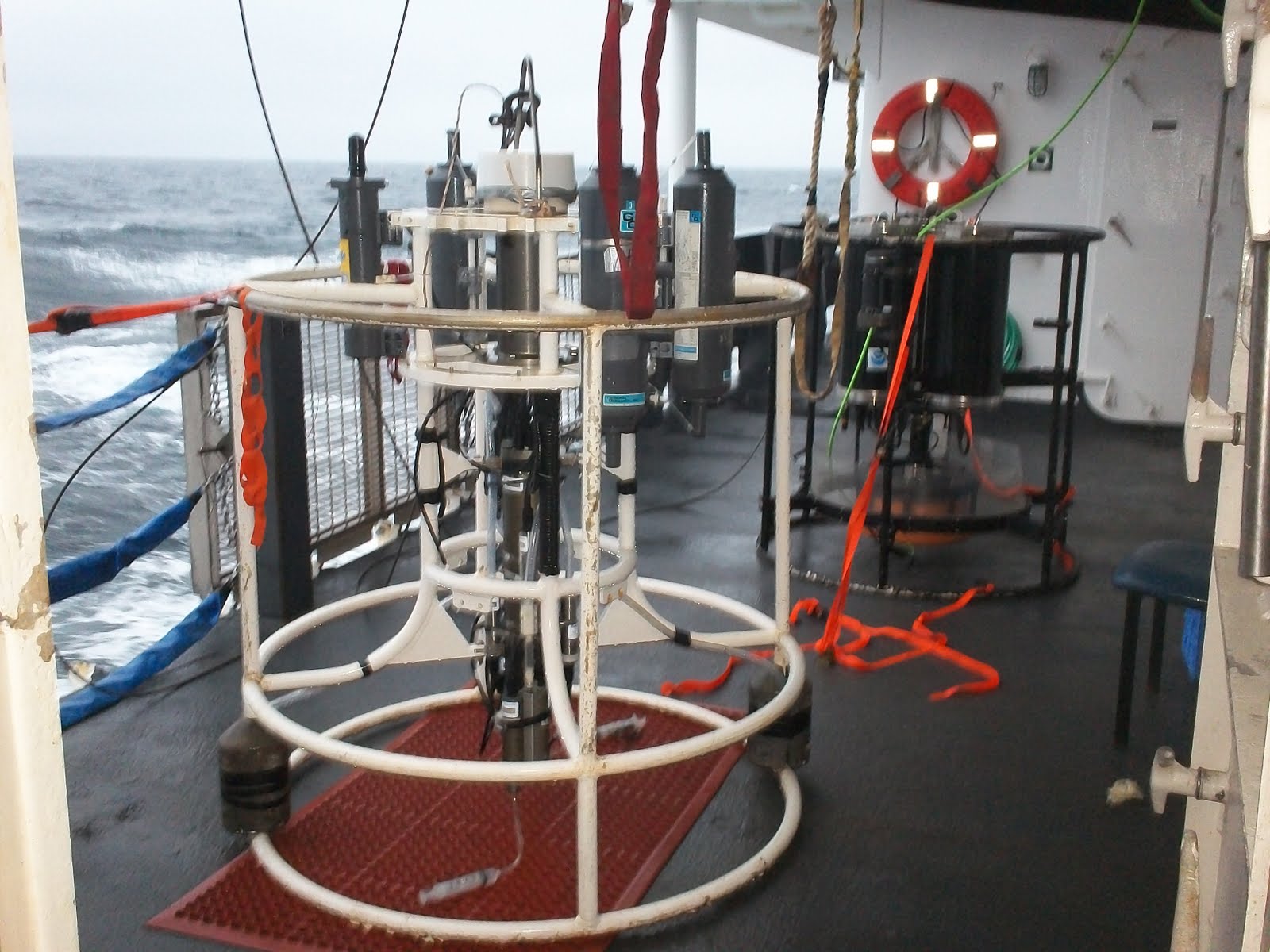
of the acoustic sonnar. The ship came to a complete stop, and using shiny metal spheres, tied to lines that were dropped on both sides and under the ship, a "ping" or sound wave was done for fine adjustment. Callibrations are done several times a year in order to for the Sonar to work accurately. The crew took advantage of the ship been anchored to do some fishing for Halibut fish, but the catch was mostly of Cod fish. We also went out on a boat ride on the Peggy D speed boat, named after Oscar Dyson's wife, around nearby bays and inlets, where we saw wildlife like sea otters and Puffin seabirds. Later on the day I was able to see where this sensitive piece of high technology was located when my good friend Robert, 2nd Engineer of the Oscar Dyson, gave a last tour of the "bowels of the beast". We went through several hatches and steps down to the lowest decks of the ship, where Robert explained the many pieces of heavy duty equipment and machinery that kept the ship on the move. First we put on Ear Muffs, because the noice level was too high (again safety first) and then we went to see the giant forward thruster in charge of moving the ship left or right, followed by even larger and louder machines: the ship's four Caterpillar Diesel Engines. These enormous and heavy duty machines were connected to large generators that 24 hours a day supplied the electricity needed to run all of the ship's electronic systems. Next we checked out another room containing the large Wastewater Treatment tank, in charge of treating all the grey water or waste water from toilets, showers, and sinks of the ship. The tank utilized a biological process where bacteria broke down all the waste, then the resulting water was treated with with a combination of chemicals and Ultra Violet (UV) light to kill any germs before being safely released into the ocean. Finally he showed me 
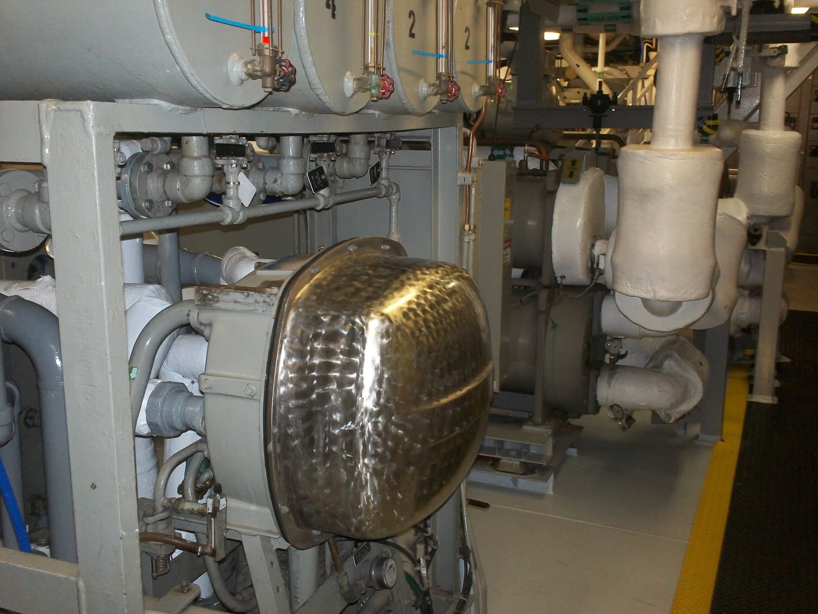
the Disalinization Plant in charge of producing up to 1,500 gallons of freshwater by Evaporation or boiling of the saltwater and then through Condensation, where the water vapor is then separate from the salt and then be collected for human consumption. Also was able to see the darn Sonar acoustic antenna at the very bottom of the ship. I was amazed at the sustainability of the Oscar Dyson and how strict were NOAA's rules concerning reduction of pollution of the oceans. After thanking Robert and the crew it was time to say goodbye to the Oscar Dyson and to all my new friends that I made during the Summer Pollock cruise. I leave with a lot of memories, a wealth of experience and resources that I hope will have an enormous impact in my students when the new school year starts in September. I know it already have made an impact not only in my students, but in my family,friends and colleagues who had followed my adventures in my Blog these past 3 weeks. I wanted to thank CO Mike Halshyk, XO Sarah Duncan, and NOAA Corps Officers Ensign Russel Pate, Ensign Amber Payne and Ensign David Rodziewicz for their diligence in taking care of us, the scientitsts on board for their patience and wealth of knowledge, as well as all the crew of the Oscar Dyson for feeding me, teaching me about life at sea, and for bringings us back safe and in one piece. I also wanted to thank Elizabeth McMahon, Elizabeth Bullock , and Jennifer Hammond from NOAA for taking care of everything, and to my fellow Teacher at Sea Story Miller. You can check out her blog http://storymillernoaa2010.blogspot.com/


Hoy temprano a las 0600 am horas finalmente llegamos de vuelta a Dutch Harbor! Desde el dia de ayer habiamos estado anclados en la isla de Unalaska, al extremo opuesto de Dutch Harbor. La tripulacion y los cientificos estaban practicando una Calibracion del sonar acustico, usando unas esferas metalicas, con el fin de ajustar las lecturas de este sofisticado instrumento electronico. Estas esferas estaban atadas a unas cuerdas finas de un lado a otro del barco (de Babor a Estribor), y con un "ping" del sonar estas eran grabadas en el monitor. Tambien fuimos en un paseo por las bahias y ensenadas cercanas en la lancha rapida "Peggy D" nombrada en honor a la esposa de Oscar Dyson, Estuvimos admirando el increible panorama de la isla de Unalaska y su vida silvestre como las Nutrias Marinas y las aves marinas Puffin. Luego en la tarde mi buen amigo Robert, 2do Ingeniero de maquinarias del Oscar Dyson, me dio un tour de la barriga del barco. Armados de linternas y de protectores de oido, debido al alto ruido de las maquinarias. Bajamos bajo cubierta por varias compuertas y escalinatas que nos llevaron primero a visitar el cuarto del Propulsor de proa, usado para darle vuelta al barco. Luego fuimos a ver los enormes Generadores de gasoil Caterpilar usados para producir la energia necesaria para mover todos los equipos electronicos abordo del Oscar Dyson 24 horas al dia. Despues fuimos a otro cuarto conteniendo el Tanque de Tratamiento de Aguas Negras de la nave donde toda el agua de desecho de inodoros y lavaderos de cocina, utilizando un proceso biologico donde bacteria descompone el desecho en el agua. Despues el agua pasaba por una lampara de Rayos Ultravioleta para matar todo germen patogeno, para ser luego descargada inofensivamente en el mar. Finalmente visitamos la maquinaria que mas me interesaba ver: la Planta Desalinizadora de Agua que estaba a cargo de producir 1,200 galones de agua potable usando agua salada del mar. Por medio de un proceso de Evaporacion la sal era separada del agua de mar, y por medio de Condensacion el agua potable es recuperada para consumo humano en el barco. Me sorprendio mucho la sostenibilidad del Oscar Dyson, donde los desechos son reciclados pues en NOAA son muy estrictos con que ninguna basura solida alcanze el mar, lo cual esta prohibido por ley. Es increible que todavia hoy en dia naves comerciales y cruceros de lujo lanzen sus desechos de aguas negras y basura al mar. Despues de darle las gracias a Robert llego la hora de decir adios al Oscar Dyson y a su tripulacion que fue mi hogar y mi familia por 3 semanas de mi vida en este verano 2010. Me marcho con muchos recuerdos y conocimientos que no solamente impactaran mis estudiantes en Septiembre sino que ya han hecho un impacto positivo. Le agradesco a todo el personal de NOAA, asi como al Oficial Comandante Mike Helshyck, Oficial Ejecutivo Sarah Duncan y demas oficiales, asi como a todo el personal de abordo por haberme adoptado y compartido tantas informaciones durante el Crucero de Pollock. Tambien le agradesco mucho a todos los cientificos abordo asi como a la Maestra en el Mar, mi colega educadora de Dutch Harbor Story Miller por su ayuda y consejos. Pueden tambien chequear su blog en http://storymillernoaa2010.blogspot.com/


Thursday, August 5, 2010

"Camera Trawl to ROV" De Camaras Aquaticas a Robots

TEACHER LOG#9
NOAA Teacher at Sea: Obed Fulcar
NOAA Ship:Oscar Dyson
Mission:Summer Pollock Survey III
Geographical Area:Bering Sea
Date:Friday, July 30, 2010

Weather from the Bridge:
Time:11:47 am
Latitude:58.47 North
Longitude:178 West
Wind Speed:2.9 knots
Wind Direction:270 West
Sea Temperature:9.7 C (49.46 F)
Air Temperature:7.2 C (44.96 F)
Barometric Pressure:1008 millibars
SCIENCE & TECHNOLOGY LOG:
During this cruise the tech crew has been very busy working on getting to work the prototype for a new Camera Trawl. This new camera array is designed to be deployed independently from the trawl and able to take pictures and footage of the fish down below. The pictures then can be analyzed to determine if the size of the Pollock is the rights one, thus reducing the need to launch the trawl net unnecessarily. So far the camera has not worked as expected and the team has done countless adjustments to it. They suspect that there is a bug in the software causing the problems. This is an example of how technology has to be tested many times in labs and in the field in order to become available for use. I always tell students in the class that many of the technology that we use today, such as cell phones, laptop computers, flat screen TVs, and even microwaves, we owe it to the scientists and technicians that developed them originally for the astronauts in the aerospace program.
PERSONAL LOG:
Coming to the ship on this cruise I was very excited because I had seen on the Oscar Dyson website pictures of an ROV (Remote Operated Vehicle) underwater robot been deployed, and was really looking forward to see it in action. I was a little disappointed when I learned that the ROV was not on board, because it was part of a test done the year before. This gave me the inspiration to implement in September a technology project i have been meaning to do with my students:to build a student ROV, using NOAA's "Rov in a bucket" activity. The students will incorporate STEM (Science, Technology, Math, and Engineering) as part of the process of learning to design, create, and build the ROV. This project will be built during/after school and once assembled and operational it can be used to broadcast pictures or even underwater footage. We could use it during our community events on the Harlem River to create awareness amongst residents that the river is cleaner than ever, and that many aquatic species inhabit the waters.
"Camaras Aquaticas a Robot Sumergibles"
Durante todo el crucero los tecnicos de la nave han estado muy ocupados en hacer funcionar una Camara Sumergible, que a diferencia de la Camara de Arrastre, que se lanza junto a la red para tomar fotos, esta tomaria fotos y video de los peces a diferentes profundidades sin necesidad de tener que lanzar la red de arrastre. El beneficio seria que esta camara usaria un programa especial que permitiria analizar en tiempo real las dimensiones de el tipo de pez expecifico. El personal tecnico realizo incontables ajustes, sin ningun exito hasta el momento. Se cree que es un malfuncionamiento del program de computadora. Este es un ejemplo de como la tecnologia es probada y examinada tanto en el laboratorio com en el campo antes de estar disponible al publico. Siempre le digo a los estudiantes que mucha de la tecnologia que usamos como el telefono celular, el microndas, y el ordenador laptop, han sido fruto de la investigacion del program aeroespacial para los astronautas. Antes de yo venir al Oscar Dyson estaba muy entusiasmado en poder ver en accion al robot sumergible ROV, o Vehiculo de Control Remoto, que yo habia visto en fotos del website. El desencanto que recibi cuando me dijeron que el ROV no estaba abordo, y que las fotos eran de una vieja mision, no fue poco. Esto me ha inspirado a en Septiembre a hacer un proyecto de STEM (Ciencia, Tecnologia, Ingenieria y Matematicas), donde los estudiantes armaran un ROV sumergible. ellos usaran estrategias similares a las que usan los technicos y cientificos en la creacion de un robot. El ROV tendra la capacidad de tomar fotos y video bajo el agua, y posiblemente ser usado en exhibiciones ambientales de la comunidad.

Wednesday, August 4, 2010

"An International Collaboration" Una Cooperacion Internacional

TEACHER LOG#8
NOAA Teacher at Sea: Obed Fulcar
NOAA SHIP:Oscar Dyson
Mission:Summer Pollock Survey III
Geographical Area:Bering Sea
Date:Thursday, July 29, 2010

Weather from the Bridge:
Time:05:56 am
Latitude:61.05 N
Longitude:178.51 W
Wind Direction: 300 N
Wind Speed:12.5 knots
Sea Temperature:8.0 C (46.4 F)
Air Temperature:9.5 C (49.10 F)
Barometric Pressure:1008 mb
Foggy Skies
SCIENCE & TECHNOLOGY LOG:
Wednesday, July 28: after a cloudy and foggy day, (Picture of a ship on Russian waters)the weather finally changed and the afternoon became sunny and clear, very pleasant to be on deck. For the past several days we have been navigating in the Russian territorial waters of the Bering Sea, for which we have permission, as testified by a letter in Russian posted on the bridge. Alaska used to be a possession of Russia, until October 18, 1867 it became a territory of the United States. We can still see Russian Orthodox churches still open today in some islands of Alaska. Pretty soon the direction of the current transect or line course, will bring us as close as 12.6 miles from land. At one point we were close to 14 miles off Cape Navarin, but there was fog in the distance and without notice the beautiful afternoon disappeared and I was not able to see Russia. Later on during the afternoon trawl, while sorting the catch of Pollock, a big fish came out on the conveyor:it was a Chum Salmon or Dog fish" said Dr. Mikhail Stepanenko, a Russian scientists working with his colleague Elena Gritsay, from the Vladivostok School of Fisheries, collaborating in the Walleye Pollock survey.to help improve the management of Russian fisheries. According to Mikhail it was most likely that the chum salmon had been born in Japanese waters, and had migrated to spawn near Cape Navarin. After I measured it then I dissected the fish to see if it was male or female. The organs were slightly different in size and location than the Pollock, but basically the same. The pillora seca was very large, engulfing the long stomach and liver, and the kidneys were right behind the swim bladder. The presence of an organ called gonads or testes confirmed that it was a male. I tried to locate the otolith, for my classroom collection bu could not locate it. There was also a very interesting fish in the catch: a Toad Lump sucker, a very cute looking fish that resembled a blow fish because it was swollen like a balloon. It had a suction orifice in the underbelly too.

Animals Seen Today:
Chum Salmon (Oncorhynchus keta), Toad Lump sucker (Eumicrotemus phrynoides)
Vocabulary:
Cape Navarin, Gonads, Pillora Seca, Orthodox, Swim Bladder

PERSONAL LOG:
I noticed that in this cruise there is an atmosphere of professional collaboration between scientists and the crew. There is also a sense of collegiate amongst all the scientists working on board the Oscar Dyson. The Pollock Survey is the primary mission, but there are other parallel missions going on: the seabird survey, done by Marty and Liz, and the marine mammal survey, done by Patty, Paula, and Ernesto. To do research on the Bering Sea is very challenging due to the remote locations, and the storms, winds, large waves, and extreme weather. The need for oceangoing vessels to work in these extreme conditions makes it very expensive, so when ships like the Oscar Dyson are deployed, different missions are planned to "piggyback" along. I was very impressed by the international collaboration in the mission, with the two Russian scientists on board conducting research on the Pollock fisheries, since part of the transects done by the Oscar Dyson covered Russian territorial waters as well. The fact the one Mexican scientist, a Filipino cook, and a Dominican teacher at sea were part of this cruise added more countries to the mission. Just like us, fish travel in different waters, local and international, and they too are citizens of the world's oceans. I wanted to commend NOAA's administration for providing career opportunities to minorities, Latinos, and women to work as scientists, technicians, Corps officers, and crew.
"Una Cooperacion Internacional" Durante todo el trayecto de este crucero de Monitoreo del Pollock he notado un ambiente de profesionalismo entre el personal cientifico y la tripulacion, asi tambien como un ambiente de colegiatura enter los diferentes cientificos trabajando a bordo del Oscar Dyson. La mision primaria es el Monitoreo del Pollock, pero a su vez hay otras misiones paralelas a la mision principal, como son el Estudio de las Aves Marinas,por Liz y Marty, asi como el Estudio de los Mamiferos Marinos, por Patty,Paula, y Ernesto. Hay que entender que hacer investigacion cientifica en el Estrecho de Bering es una tarea logistica complicada por lo remoto del lugar, lo extremo del clima, asi como gigantescas olas. Solo se pueden usar barcos de navegacion oceanica que son muy costosos, por lo que cuando embarcaciones como el Oscar Dyson son lanzadas, multiples misiones son planeadas al mismo tiempo tambien. Me llamo mucho la atencion la cooperacion internacional, especialmente los dos cientificos rusos a bordo, que tambien relizaban estudios del Pollock, lo cual tiene mucho sentido, debido a que gran parte de la investigacion cubria aguas territoriales rusas. El hecho de que un biologo Mexicano, un filipino (Ray el cocinero), y un Maestro en el Mar dominicano tambien forman parte de este crucero le agregan mas paises a la mision. Yo quiero felicitar a la administracion de NOAA por proveer oportunidades de carreras profesionales tanto a minorias, como a Latinos, y a mujeres para trabajar como cientificos, tecnicos, Cuerpo de Oficiales o como tripulantes. Yo creo que esto es un gran incentivo para que mas jovenes estudiantes de escuela intermedia y secundaria puedan perseguir carreras profesioanles en Conservacion Ambiental.

"Trawling in the High Seas" Echando La Red en Alta Mar

TEACHER LOG#7

NOAA Teacher at Sea: Obed Fulcar

NOAA Ship: Oscar Dyson

Mission:Summer Pollock Survey III

Geographical Area:Bering Sea

Date:Wednesday, July 28, 2010


Weather from the Bridge:

Time:04:42 am

Latitude:61.04 North

Longitude:178.06 West

Wind Speed:10.74 knots

Wind Direction:50 degrees North

Sea Temperature:8.99 C (48.02 F)

Air Temperature:8.2 C (46.76 F)

Barometric Pressure: 1010.1 millibars

Cloudy Skies


SCIENCE AND TECHNOLOGY LOG:

Friday, July 23: The Walleye Pollock survey has been conducted since 1979, every summer by MACE (Midwater Assessment and Conservation Engineering) part of the Alaska Fisheries Science center (AFSC). The sea was quite calm compared to the last days, giving us a break from sea sickness. The other day I missed the trawl, but I will not today. As soon as we saw the fish in the Acoustic sonar screens I knew it was trawling time, so I ran up to the bridge to witness the whole thing. The started deploying an Aleutian Wind Trawler or AWT net that was attached to a giant winch with huge ropes and chains. The long net had a front orange section with smaller openings compared to the back. I was invited to come to deck by deckhand Buddy Gould. He is a veteran New england fisherman from Rhode Island, now living in Florida. I asked permission from Commanding Officer CO Mike Hashlyck , and went on deck wearing a PFD, and a hard hat. After trawling the net behind the ship for what felt like an eternity, it was finally hauled back, the catch of Pollock was then spilled into a box leading to the wet lab for slicing and dicing. I went inside an put on rain boots, a plastic jacket and a jumpsuit, plus elbow high plastic glove and got down to slice and measure Pollock. While sorting out the fish we found a Pacific Flounder and a Rock sole fish, both flat bottom fish. For the next several days while conducting the survey, I kept dissecting the content of the stomachs of everal fish to find out what they have been eating. I learned that the main diet of Pollock was made up of animal plankton called Euphasiids, also known as krill. These small organisms are arthropods or segmented invertebrates (without internal skeleton), and just like shrimps, and crabs, their bodies are covered by an exoskeleton or shell, with paired antennae, pincers, and legs. They were present in the stomach of all the specimens in a pink color mass. There was one large maturity level 4/5 Pollock that when I opened its stomach, a large Northen Pacific shrimp came out of it. Then in later catches I observed that all the stomachs were very dark-blue looking. When I opened the stomach of one fish there was a dark purple mass of another arthropod called Pelagic amphipods, or sea fleas. Amphipods swim drifting in the water column and are larger than euphasiids or krill, wich instead formed massive swarms swimming at great depths by day but heading to suface by night. I was able to witness this pattern when once the echogram from the acoustic radar showed a swarm of krill drifting from the surface to the bottom as the sun was rising.


Animal Species observed:


Arrowtooth Flounder (Atheresthes stomias), Northern Rock Sole fish (Lepidopsetta polyxystra), Northern Pacifi Shrimp


VOCABULARY: Amphipods, Arthropods, Ecograms, Euphasiids, Exoskeleton, Invertebrates, Krill


PERSONAL LOG:I realized that this tiny organism (the krill) is crucial for the survival not only of many animals in the ocean, but ultimately of us humans. We have historically harvested the rich waters of the Bering Sea for food, and most recently as a source of cheap protein to feed cattle and even pets. Disasters such as the recent massive oil spill from the tracgic explosion of the Deep Horizon oil platform, own by giant multinational BP, and the Exxon Valdez oil spill in Alaska during the 80's are examples of how fragile the marine ecosystem is. But the number one threat to ocean fisheries is actually overfishing exploitation of the ocean resources. I heard stories about the foreign fleets that come to Russian waters and overfish with impunity, while at the same time processing, canning, and packing all their catch aboard their ships, taking it all back to their countries, without sharing any jobs opportunities with the local communities. Historically local fishing fleets have fished sustainably, bringing back to local ports the catch, allowing canneries, and fish markets to also benefit from it. We have to spread the word about this injustice and begin to question our own habits, to see what can we change in our consumption that will have a positive impact in this urgent matter.


"Echando la Red en Alta Mar" El mareo de ayer no me permitio participar en la pesca del Pollock, pero no hoy! Tan pronto me entere, subi al puente para observar lo todo. Mi buen amigo del personal de cubierta, Buddy Gould pescador de Rhode Island radicado en la Florida, me invito a bajar a cubierta. Despues de ahbe asegurado permiso del Oficial Comandante Mike Holshyck, baje a la cubierta con chaleco flotador y casco de seguridad a cuestas. La anaranjada Red de Arrastre fue lanzada al mar por unos gigantescos rollos de cables y cadenas pesadas. Luego de lo que parecio una eternidad, la red fue traida a bordo y la pesca fue depositada en una rampa en la cubierta por una grua pesada. Yo fui adentro rapidamente y me vesti con guantes, poncho, pantalones, y botas de plastico y me puse las manos a la obra: a picar los pescados! Durante el proceso note que los estomagos de los pescados cambiaron de color rosado a color purpura. El contenido de los estomagos incluia un plankton-animal llamado Euphasiid o Krill, un artropodo (invertebrados parecidos al camaron y el cangrejo), asi como otro llamado Amphipods, los cuales constituyen la dieta primaria de especies de peces como el Pollock, y el Salmon, asi como de las ballenas jorobadas. El krill no solo es primordial para estas especies marinas sino para la raza humana, que depende de las reservas alimenticias del Estrecho de Bering como gran fuente de proteina. Es lamentable que este fragil recurso natural no sea celosamente cuidado, cuando vemos como el desastre del derrame de la Plataforma Petrolera Deep Horizon en el Golfo de Mexico, y en los 80's del Exxon Valdez en Alaska, puede facilmente hacer desaparecer la pesqueria. Pero el enemigo numero uno de este recurso natural es realmente la pesca desmedida por parte de flotas pequeras extranjeras que viene a las aguas del Estrecho de Bering, pescando indiscriminadamente. Estos barcos no solo pescan, si no que procesan y empaquetan todo a bordo sin dejar si quiera oportunidad a las comunidades locales de participar del beneficio sostenido. Tenemos que hacer eco de esta injusticia y autoanalizar nuestros habitos a fin de ver que podemos cambiar para poder hacer un impacto positivo.

Monday, August 2, 2010

"Walleye Pollock Survey"Monitoreo del Bacallao

TEACHER LOG#6
NOAA Teacher at Sea: Obed Fulcar
NOAA Ship:Oscar Dyson
Mission:Summer Pollock survey III
Geograpical Area:Bering Sea, Alaska
Date:Tuesday, July 27,2010

Weather from the Bridge:
Time:05:26 am
Latitude:59.27 N
Longitude:176.58 W
Wind Speed:11.8 knots
Wind Direction:219 degrees W
Sea Temperature:9.4 C (48.92 F)
Air Temperature:8.27 C (46.88 F)
Barometric Pressure:1008 mb
Foggy skies
SCIENCE & TECHNOLOGY LOG:
Thursday, July 22 (continuation): After my bout with motion sickness, I felt a lot better so I decided to finish my shift. Around 1400 (2pm) upon returning to the Acoustic lab suddenly I smelled the fish:they were trawling for Pollock! I rushed to the wet lab to find Darin and Story, my fellow Teacher at Sea, and a young scientist named Kathy Hough already in full gear, surveying the Pollock. The catch was coming down a chute and spilling over a conveyor where the fish was sorted out by sizes. The targeted size Pollock was placed in crates to record the weight on a digital scale, while the rest, together with any giant jelly fish, or Northern Sea Nettle (Chrysaora melanaster) caught in the net were return overboard. The next part of the survey involved dissecting each fish using a scalpel, making a cut across the left side of the underbelly in order to determine the sex and the content of the stomach. There was a large chart showing pictures of the way the female reproductive organs or ovaries and the male testes looked like at each level or size from 1 to 4. The males were named "blokes" and the females "sheilas" (I believe these to be Australian terms). After the dissection the length of each fish was recorded automatically using a white measuring board with a yellow metric ruler featuring a magnetic strip. The final step involved selected specimens getting a cut above their heads in order to remove two tiny ear bones or "Otolith" that every bone fish have. They are used to determine the growth of the fish, and together with samples of stomach content they were preserved and placed in a freezer to be sent to a NOAA laboratory in Seattle for further analysis.
PERSONAL LOG:
Working with the Pollock Survey has really hit home. All this fish made me think about "Sharky" our Brook Trout resident born 3 years ago in our cold water aquarium at MS319, as part of "Trout in the Classroom" a program where New York city students learn about conservation by raising trout from eggs to fingerlings, or juvenile size, and then they get to release them in a cold water stream upstate New York. Trout is another fish that is part of the Alaska ecosystem, living and spawning in streams along the coast. The trawling reminded me of when we cast our Seine nets on the Harlem River, as part of our Environmental Education after school program, in order to identify the fish and collect the data, just like the survey. I made a great connection when Darin, the young scientist working with us on the Pollock survey, told me that Pollock is called "Bacallao" in Portuguese. This reminded me that back in New York City, I noticed that for the past years in every "bodega" (spanish grocery store) the packaging containing Bacalao nowadays say Pollock instead of what traditionally used to be Cod fish. Apparently there is an specie of Atlantic Pollock that has been historically consumed in Europe and in the Mediterranean countries of Portugal and Spain, so it is no surprise that we have incorporated Bacalao as part of the traditional cooking of the Dominican Republic. Every self-respecting Dominican knows that Bacalao is a staple of Dominican cuisine. I never liked fish as a child, and I remember that Bacalao was the only fish I actually enjoyed eating until this day, well seasoned in tomato sauce and onions, accompanied with rice beans or with yucca. This reminds me of another fish part of the dominican culinary culture: a form of dried, smoked fish (very smelly) known as "Arenque". This fish, widely sold in bodegas and open markets is usually cooked in a paella style rice called "locrio". I had a hunch that Arenque was Spanish for Herring, another fish like Pollock, found in the waters of the Bering Sea. After a little research I found out that indeed Arenque and Herring were the same. Arenque is the Spanish word for the Atlantic Herring (Clupea harengus), commonly fished and consumed in Spain, Portugal, and South America. Humm... Arenque=harengus (Latin), whence the English name Herring. Eureka! Days later some Pacific Herring was caught in one of the trawls and I noticed it had large shiny scales, dark blue on the top, and silver ones in the underbelly. Some where cooked for diner that night and the meat was very tasty, looking like... Arenque.
Animal Species Observed:
Northern Sea nettle jellyfish, Pacific Herring (Clupea pallasi), Walleye Pollock (Theragra Chacogramma)
New Vocabulary:
Arenque, Bacallao, Bodega, Brook Trout (salvelinus fontanelis), Herring, Otolith, Seine Net, Scalpel


"Monitoreo del Bacallao"

El mareo no me permitio participar en la pesca de hoy, pero desde que me senti mejor fui directo a la cubierta donde una grua de carga habia depositado los peces en una rampa de aluminio hacia el Laboratorio Humedo. Ya adentro encontre a Story, mi colega maestra, Darin, y una joven cientifico llamada Kathy, que ya estaban trabajando con los pescados. El proceso consistia en separar el Pollock de otras especies como el Herring, y la Medusa Gigante, que despues de tomarse el peso eran arrojados por la borda. El Pollock era pues separado por sexo, entre "Blokes" machos, y "Sheilas", hembras (terminos australianos), y esto se hacia por medio de diseccion, donde tambien se analizaba el contenido del estomago, usando un poster con fotos de los organos internos del Pollock a diferentes edades como guia.

Luego de la diseccion procedimos a medir cada uno de los pescados, Story los machos, y yo las hembras, usando una tabla blanca con una cinta metrica amarilla, que contenia una cinta magnetica. Cada pescado era medido automaticamente al colocarse cuidadosamente a lo largo de la cinta metrica, y el conteo era registrado en una pantalla de computador con el nombre del cientifico. Me senti muy orgulloso al ver mi nombre como el cientifico de turno! El paso final era el de remover el "Otolith" o hueso del oido, usado para medir el crecimiento del pez, que junto a el contenido del estomago se preservaba para enviarse a los laboartorios de NOAA en Seattle. Tanto pescado me hizo pensar en "Sharky" la trucha mascota que hemos estado criando en el aquario de la escuela como parte del programa "Truchas en El Salon de Clases". Tambien me recorde de cuando mis estudiantes tiran las redes de pesca para estudiar las especies acuaticas del Rio Harlem, como parte del programa de Educacion Ambiental que dirijo en la escuela MS319. Tambien estudiando el Pollock, aprendi que los portugueses le llaman "Bacallao", casi identico a la palabra "Bacalao", que es como lo llamamos en Republica Dominicana. Otro pez que junto al Bacalao son parte de la cocina tradicional dominicana es el Arenque. Yo tenia una corazonada que el Arenque era la misma palabra de un pez que en Ingles se llama "Herring", tambien muy abundante en Alaska. Despues de hacer una investigacion, Eureka! resolvi el misterio. Arenque es la palabra usada para referirse al Clupea harengus o Arenque Atlantico, de donde viene tambien el termino Herring=harengus=Arenque. Todo Dominicano que se respeta sabe que el Bacalao y el Arenque son parte de la comida tradicional dominicana.

Sunday, August 1, 2010

"Technology in the High Seas" Tecnologia en Alta Mar

TEACHER LOG#5:
NOAA Teacher at Sea: Obed Fulcar
NOAA Ship: Oscar Dyson
Mission: Summer Pollock Survey III
Geographical Area:Bering Sea
Date: Monday, July 26, 2010
Weather from the Bridge:
Time: 04:18 am
Latitude:60.02 N
Longitude:176.59 W
Wind Speed:15.2 knots
Wind Direction:180 degrees South
Sea Temperature:9.2 C (48.56 F)
Air Temperature:8.2 C (46.76 F)
Barometric Pressure: 1009.7 mb
Cloudy Skies
SCIENCE & TECHNOLOGY LOG:
The purpose of this mission aboard the Oscar Dyson is for a team of scientists to conduct a survey of the Bering Sea Walleye Pollock population, in oder to help the government establish sustainable commercial fishing quotas that will allow to manage a healthy population of this abundant, but yet fragile species. In order to carry the Pollock survey it is necessary to perform a combined Acoustic -Trawl Survey where acoustic data is collected along a line transect and then a Trawl (net) is used to catch a sample quantity of the fish observed in the acoustic data.
In the Acoustic Lab there are a number of video monitors displaying several screens. Taina Honkalehto, the Chief Scientist of the Oscar Dyson explained to us how the acoustic sonar operates. First the acoustic survey relies on Sonar technology where it sends an acoustic "ping" powerful enough to detect fish at any depths. It travel back and forth between the bottom and the surface of the ocean, and its signature then registered on a video screen, allowing us to "see" where the fish are and the precise location. One screen shows an actual graph, or "echogram", displaying several layers at different depths in colors ranging from gray, blue, green, yellow, orange to red. The dark red color represented the ocean floor, and the green/blue dots represented the fish. The darker the color, the more dense were the objects. Another sceen showed the location of the ship on a Nautical Topographic Map, including a red line showing transects (line routes) followed by the ship., as well as icons showing the points where the fish has been detected along the way. Taina then uses this constant information to decide how to instruct the bridge into when where to position the ship in order to launch the trawl net. The trawl net used is known as an Aleutian Wing Trawl (AWT). It is equipped with specialized sensors that show in the video monitor where the fish are in relation to the net. Once the trawl is finished the net is then hauled back and the contents spread on deck for sorting out and identification. Target species such as the Walleye Pollock will be separated to be measured and weight then released overboard. Some of the catch will be kept for dissection to determine the sex, and to determine the age by studying the Ear bone or Otholith, that registers the gowth of the fish by marking each year with a dark ring, just like the growth rings on a tree. The otolith, stomach contents, and sample fish are carefully placed in vials, mesh and ziploc bags to be sent to NOAA's Alaska Fisheries Science Center in Seattle for laboratory analysis. all this information will tell us how healthy is the Pollock population o the Bering sea, and help determine commercial fishing quotas for next year's fishing season.
PERSONAL LOG:
I could not help to think about the amount of technology involved in the Pollock survey. I am pretty sure that Mr.Sanchez, my school technology teacher would be excited to see all the servers, CPUs, monitors, and all the coputer harware and gear used around here onboard the Oscar Dyson. I believe that the middle school students of the Maria Teresa Mirabal school MS319 will be right at home, since they are accustomed to used technology as part their everyday school work. From getting their password to log on into the school website network, using Netbooks for interactive podcast lessons, to taking online reading comprehension quizzes, these are part of a technology rich learning environment. Technology literacy is basic for a 21st Century education. But technology alone is not enough if we don't tech the kids how to apply it in the real world. One example of the importance of using mathematical skills in the real world is best demonstrated in the Acoustic survey when calculating the estimated size of the fish that appears as dots on the Acoustic radar screen. The sonar software allows to isolate the fish by scanning a selected area of the monitor display and calculating the average decibel (sound unit) value per dot representing a fish. Knowing this value we can replace it in a given formula and easily calculate the approximate size of the fish in order to start trawling.
VOCABULARY:
Aleutian (Alaska native group), Dissection, Decibel, Nautical Topographic Map (underwater map of the ocean floor), Otolith, Transect

"Tecnologia en Alta Mar" El proposito de la Mision abordo del Oscar Dyson es la de tomar un muestreo del Pollock o Bacalao para poder determinar que tan robusta esta su poblacion, a fin de poder determinar las cuotas apropiadas a ser dictadas a las flotas de pesca comercial. Para poder hacer este muestreo es necesario el uso de tecnologia de Sonar Acustico en combinacion con el uso de la Red de Arrastre. Todo comienza en el Laboratorio Acustico donde un numero de pantallas de monitor muestran diferentes imagenes. Taina Honkalehto, la Cientifico en Jefe del Oscar Dyson, nos explico que la tecnologia de sonar consiste en enviar un "ping" acustico que es lo suficiente poderoso para viajar de la superficie al fondo del mar de ida y vuelta, penetrando las capas mas profundas. La onda acustica que es reflejada es pues registrada en las pantallas permitiendonos ver una imagen de la ubicacion de los peces, y la precisa profundidad. Una pantalla nos muestra una grafica en tiempo real con lineas de diferentes colores que van del gris, azul, verde, amarillo, hasta el rojo que representa el fondo del mar. Otra pantalla nos muestra un Mapa Topografico Nautico que incluye una linea roja mostrando la linea de transeccion o el curso que sigue la nave. Con toda esta informacion Taina puede instruir al puente sobre que ruta de navegacion debe tomar la nave a fin de hacer la pesca. La red de Arrastre Aleutina, empleada en el muestreo, esta equipada con sensores especiales que indican en la pantalla la ubicacion de los peces en todo tempo. Realmente tienen la pesca totalmente calculada a lo mas minimo! Tan pronto se termina la pesca, el contenido de la red es pues depositado en la cubierta donde los peces seran separados para ser medidos y disecados a fin de averiguar el sexo y la edad. Muestras del contenido del estomago, y especimenes seran recogidos a fin de enviarlos a los laboratorios de NOAA en Seattle para determinar si la poblacion estara optima para la peca de la proxima estacion.

Wednesday, July 28, 2010

"Riding the High Seas" Navegando en Alta Mar


TEACHER LOG #4
NOAA Teacher at Sea:


Obed Fulcar
NOAA Ship: Oscar Dyson
Mission:Summer Pollock Survey III
Geographical Area:Bering Sea
Date:Saturday, July 24, 2010
Weather from the Bridge:
Time:05:59 am
Latitude:61.42 N
Longitude:176.57 W
Wind Speed:13.44 knots
Wind Direction:90 E
Sea Temp:8.49 C (47.28 F)
Air Temp:7.0 C (44.60 F)
Barometric Pressure:1005.98 mb

Science & Technology Log:
Thursday, July 22: After a night of swinging and swaying from the waves at high seas, I am somewhat used to it already. Today is the start of my new shift from 0400 in the morning until 4:00 pm in the afternoon, 12 hours on, 12 hours off. Since yesterday we left the continental shelf and we are heading to deeper waters. There was a scheduled trawl to be done early this morning, but the Acoustic Lab reported no fish at all on the screens. As part of the survey it is necessary to perform a CTD launch every morning at sunrise. CTD stands for Conductivity, Temperature, and Depth, explained Darin Jones, one of the young scientists in charge of the Pollock survey. The CTD unit is made up of a series of bottles used to collect water samples at different depths, and also includes remote sensors to collect data such as sea temperature, salinity, depth, water pressure, and fluorescence. Fluorescence is the presence of Chlorophyll in the water which depends on the amount of sunlight that penetrates the ocean, indicating the presence of Phytoplankton (algae and other microscopic plants). They rely on sunlight to produce the energy that zooplankton growth is dependent upon. Zooplankton is the foundation of the Bering Sea food chain, since is made up of krill, small shrimp like crustaceans that are the primary source of food for commercial fish such as Pollock, Cod, Salmon, and pretty much any other fish in the North Pacific Ocean. As the CTD is dropped the ship needs to stop in order lower the unit, which is attached by cables to an A-Frame crane, including one to transmit data. The CTD can only be used to depths of 600 meters, so another device called the XBT for Expendable Bathy-Thermograph (for depth and temperature) is used for depths up to 700 meters. It can also be launched manually while the ship is in motion, and data is transmitted through a thin copper wire that splits, hence the name "Expendable". Once the CTD is hauled back onto deck, the water bottles are drained and samples taken for dissolved oxygen (DO) analysis. DO is sequestered using chemicals that react with the oxygen taking a solid form that preserves it for lab analysis.
Personal Log:
Last night I took motion sickness pills to keep me from getting seasick. After breakfast weather got really bad, with waves up to 6 feet, battering the Oscar Dyson. These conditions, combined with a heavy breakfast, made feel really dizzy, and next I know I was throwing up. My roommate, Vince Welton, who is also the ship's tech guy, got me some very tasty saltine crackers, and medication, that help me feel better. I laid down on my bunk bed and doze off while listening to some Jazz by Michel Camilo. While trying to rest the waves were crashing into the hull of the ship with a loud noise, while the ship kept going up and down. I was thinking about how seafarers of the past and the conditions aboard were so much different than today. Ocean going trips now are made much easier by the technology and modern amenities commonly found on board. Staterooms with bath, galleys or kitchens fully equipped with fridge, microwave oven, and entertainment rooms with flat TVs and DVD players are the norm. I kept thinking that the next 2 weeks on board the Oscar Dyson will be a lot like space travel, will all the walking up and down stairs from deck to deck, closing of hatches, and not been able to step outside the ship for a walk until reaching port. The connection I can make about the CTD is that it reminds me a lot of the citizen science data collection and water quality monitoring I conduct with my students after school on the Harlem River, as part of "A Day in the Life of the Hudson River" a yearly event sponsored by NYSDEC (NY State Dept of environmental Conservation) and Columbia University Lamont-Doherty Laboratory. just like in the CTD we collect samples of water from the river to test for Dissolved Oxygen, Chlorophyll, PH, Salinity, Nitrates, plus soil samples from the mudflats. When we collect the chlorophyll samples we use the same methods just as it's done on the Oscar Dyson, squirting the water through a circular paper filter until it turns brownish. I am planning a lesson for next school year called "NOAA in the Classroom:Student CTD Activity" where using a student water sampling bottle my Environmental Science Club class will collect water from the Harlem River at different depths with the help of our wooden boat "Boca Chica" built after school. We test the samples for DO, Salinity, PH and other protocols using a LaMotte water quality test kit to monitor the health of the Harlem/Hudson River Estuary. This data will be reported to the GLOBE.gov Program website to be used by scientists and schools all over the world. My middle school MS319 is a GLOBE Program partner school, and also we will be reporting data from our new Wireless Weather Station. I strongly believe that students learn science by doing science!
"Navegando en Alta Mar"
Jueves, 22 de Julio: Hoy comence my primera guardia de las 0400 am a las 4pm. Desde que zarpamos del puerto de Dutch Harbor hacia aguas profundas me habia librado del mareo, pero finalmente me agarro.

El mal tiempo de hoy temprano, con violetas olas que golpeaban la nave de hasta 18 metros, mas un desayuno muy pesado me provocaron unas nauseas que termine en mi camarote vomitando y tirado en la cama. Despues de tomarme una medicina y de comerme unas galletitas de soda, me tome una siesta y me levante mucho mejor. El Sonar Acustico de la nave no detecto presencia de peces por lo que fui a ver el lanzamiento de un CTD o unidad de Conductividad y Profundidad Termal. El CTD contiene botellas para recoger muestras de agua y sensores para medir la temperatura y salinidad del mar hasta 600 metros. Para medidas mas profundas de hasta 700 metros se usa una unidad manual desechable llamada XBT. Ambas unidades son usadas para obtener datos cientificos como el nivel de Oxygeno disuelto, Salinidad, Profundidad, y Florescencia (nivel de clorofila), la ultima es muy importante pues refleja la abundancia de algas microscopicas de las que depende el Zooplankton. El zooplankton esta compuesto de minusculos crustaceos que son la base del ecosistema alimenticio del Estrecho de Bering, del cual dependen especies comerciales como el Bacallao, Salmon y Arenque, asi como casi toda especie de pez en el Oceano Pacifico Norte. El uso del CTD es muy parecido al trabajo que hago con mis estudiantes analizando las aguas del Rio Harlem. Estos jovenes cientificos tambien toman muestras de agua y practican analisis de campo para Oxygeno disuelto, PH, Nitratos, Salinidad e incluso pruebas de Clorofila, como parte de un evento anual llamado "Un dia en la Vida del Rio Hudson" . En este evento organizado por el Laboratotio Lamont-Doherty de la Universidad Columbia, y el Depto de Conservacion del Estado de NY, participan escuelas a todo lo largo del Rio Hudson, recaudando datos cientificos sobre el rio. Pensamos usar a "BOCA CHICA",un bote de madera que armamos de tarde, para una practica de CTD tomando muestras de agua del rio, analizarlas, y reportar los datos en el internet. Tambien mis estudiantes de la Escuela Intermedia Maria Teresa Mirabal Ms319, de origen dominicano en su mayoria, aprenden ciencia ambiental al tomar datos de la Estacion Metereologica ubicada en el techo de la escuela. Ellos reportan los datos via internet en la pagina web del Programa GLOBE.gov, para ser usados por cientificos y estudiantes por todo el mundo.

Monday, July 26, 2010

"All Hands on Deck" Manos a la Obra

Teacher Log #3
NOAA Teacher at Sea: Obed Fulcar
NOOA Ship: Oscar Dyson
Mission: Summer Pollock Survey III
Geographical Area: Bering Sea, Alaska
Date: Thursday, July 22, 2010

Weather from the bridge:
Time: 0355 am
Latitude:58.22 N
Logitude:175.10 W
Wind speed:19.48 kts
Wind Direction:230 W/SW
Sea Temp:8.10 C (approx. 46.58 F)
Air Temp:8.72 C (approx. 47.70 F)
Barometric Pressure:1090.0 mb
Cloudy skies

Science and Technology Log:
Yesterday afternoon we had a Fire/Emergency drill, just like we do in school. Safety is definately big around here. Everywhere you look there is an orange sign for an EEBD (Emergency Escape Breathing Device), to be used in case of a fire,to avoid intoxication from breathing the smoke. Fire is the number one enemy in a ship, and it can have disastrous consequences at sea. For the fire drill we had to follow a path leading to a safe room where we had to be accounted for. Fire stations are in every corner with Fire Hoses, and even Fire Axes. Next we had to do an Emergency drill where we had to practice abandoning ship. I had to grab my assigned Immersion suit, or "Mustang suit", also known as a "Gumby suit", which is an orange jumpsuit, made of neoprene (the material used in drysuits or diving suits). It is supposed to keep you warm and alive in the event you have to abandon ship and hit the icy waters of the Bering Sea. I had to practice putting on the cumbersome but necessary safety gear. Everyone is issued one that has to be kept in their staterooms. I had to pack it again and put it back in it's original bag after I finished trying on. As part of the emergency drill we also had to gather around the ship's Life Rafts, that where contained inside a set of 3 white canisters on both sides of the ship (Port (right), and Starboard (left) ). I was surprised to see my name on the evacuation plan assinged to Life rafts 2-3. Each life raft can hold up to 20 people inside, and many more, until rescue arrives. I noticed that aboard the ship chairs, tables, cabinets and pretty much anything that can get loose during bad weather are safely anchored to avoid falling off. There are safety signs everywhere you go reminding you to be ready at all times. Also safety is No 1 whenever working on the deck near the water, from the use of a PFD (personal Flotation Device), a hard hat, due to cranes and heavy duty cables, to a safety harness to be anchored to the boat. Eye wash emergency stations are everywhere, as well as signs telling you to use hand sanitizer at all times.

Personal Log:
Safety first: Just like in school, the possibility of a fire can lead to disaster and tragedy. It is a serious matter that we should all be prepared for. Fire drills in school, like in the Oscar Dyson, help us get familiar with our nearest exit starcase, and to know a safe place to gather up away from the fire, just like when we go across the street from our school during a drill. Also as a member of the Washington Heights, Manhattan North CB12 CERT (Community Emergency Response Team), it is my job to help educate the community at large about fire emergecy preparedness awareness. Fire is the #1 emergency affecting buildings in New York City and every resident is at risk of been affected. Since 9-11, NYC OEM has been promoting emrgency awareness by educating and getting the public involved in emergency awareness ranging from fire, heat waves, to hurricane emergencies. I encourage everyone to visit ReadyNY.org and Ready.gov to learn more about protecting yourself, family and neighbors in case of an emergency. Ayer tuvimos una practica de Evacuacion de emergencia y de Incendio. Practicamos siguiendo el Plan de Evacuacion en caso de fuego reuniendonos en un lugar designado (en este caso el salon de Conferencias). Tambien practicamos el abandonar la nave, donde teniamos que ponernos los Trajes de Supervivencia o de Inmersion, requeridos por ley. En caso de que al abandonar la nave nos protegerian de las gelidas aguas del Estrecho de Bering manteniendonos secos y abrigados si llegaramos a caer en el mar. Me sorprendi mucho de ver mi nombre en la lista de evacuacion ya asignado a una de las Balsas Salvavidas, de la nave. Hay dos juegos de 3 balsas en ambos lados de la nave (Babor o derecha, y Estribor o izquierda) con capacidad para 20 personas. La seguridad es No 1 abordo del Oscar Dyson, con letreros en todas partes indicando desde el uso de Chalecos Salvavidas, Trajes de Inmersion, hasta estaciones de emergencia, con mangueras y hachas de incendio. Asi como en la escuela y en los edificios todos debemos estar educados en que hacer en caso de incendio, que es la emergencia #1 en la Ciudad de Nueva York.

Friday, July 23, 2010

A view from the Bridge/ Desde el Puente del Barco

NOAA Teacher at Sea: Obed Fulcar
Teacher Log # 2
NOAA Ship: Oscar Dyson
Mission: Summer Pollock Survey III
Geographical Area:Bering Sea Shelf
Date: Wednesday, July 21, 2010
Weather from the Bridge:
Time: 0345 pm
Latitude: 57.23 degrees North
Longitude:173.33 degrees West
Wind: 12 knots
Direction: 257 degrees West
Sea Temperature: 8.5 degrees C
Air Temperature: 8.85 degrees C
Barometric Pressure: 1020.0 mb
Skies: Partly Sunny
Science and Technology Log:
Yesterday, Tuesday July 20, we finally left Dutch harbor, once all the delayed scientific equipment arrived. I was later told that it included some new and sophisticated technology to track and measure fish underwater. We climbed up to the "flying bridge" at the very top of the ship to see the view of Dutch harbor behind us and the open ocean ahead. After that we came down to the bridge where Acting Executive Officer XO Sarah Duncan, Ensign Amber Payne, and Buddy Gould from the Deck Department gave us a tour of the bridge. They explained that the panels of navigational instruments used to sail the ship included Radar screens, to detect any vessels or ships in the proximity, one for long range, and another for short range, showing any ships close by. The screens show the many readings from instruments on board such as wind speed (in knots), Wind direction (in degrees), Latitude, Longitude, and Air Pressure (in millibars). Next we received a demonstration in how to chart a course using the Electronic chart. I was surprised to understand the navigational terminology, (Iguess my Basic Sailing class is paying off), such as true wind, leeward, aft, forward, et...
I asked if they still used paper Nautical Charts and the answer was yes, they use them to plot the course of the ship using pen, ruler, and compass. I was surprised to know that even with all this technology even though the ship course and navigation is done completely electronically, they still rely on pen and paper charts as back up! On the bridge were also two scientists fro the US Fish and Wildlife service working on Seabird research, as part of the Bering Sea Integrated Ecosystem Project, a multidsciplinary study that is looking at how climate change is affecting the ecosystem of the Bering Sea. liz and Marty were both working from the bridge with binoculars, observing and counting all seabirds within 300 meters from the ship. armed with a laptop computer connected to the ship's navigational system they were able to count and input the GPS location (latitude/longitude) of every sighting of a seabird, and plot a GIS graph in real time. I found this to be really cool! We saw seabirds found on the Bering sea such as Black-footed Albatross, Northern Fulmar, Tufted/Horned Puffin, Fork-tailed Storm Petrel, and Thick-bill Murre.


Personal Log:
Today is Day 4 of the mission and so far I have done pretty well in terms of motion sickness. A calm sea has been a great factor and has allowed me to get adjusted to life at sea. I am surprised to find myself at home in my my bunk bed, and haven't had any difficulties sleeping at all, though I do miss my bed. The long schedule from 0400 to 1600 (4pm) full of activities has been of help keeping me busy. The food is great thanks to Floyd the master cook with a variety of international food and home baked pastries. I was also impressed by the international collaboration in this mission, with two Russian scientists on board conducting research on the fisheries of the Bering Sea since part of the transects or line passess done by the Oscar Dyson cover Russian territorial waters as well.
New Vocabulary Words;
Nautical charts, Radar, Latitude, Longitude, GPS (Global Positioning Satelite), Leeward (opposite to wind), Forward (front of ship), Aft (back of ship)

Animals seen today:
Black-footed Albatross, Northern Fulmar, Tufted/Horned Puffin, Fork-tail storm Petrel, Thick-bill Murre
Bitacora Marina #2: Ayer martes, 20 de Julio finalmente zarpamos hacia alta mar. Los oficiales del Oscar Dyson nos dieron un tour del puente explicandonos los sofisticados instrumentos de navegacion electronica como Radares, sonar acustico, y sistema global de ubicacion por satelite (GPS).A pesar de tanta tecnologia, todavia se grafica el curso de la nave usando Cartas Marinas, compas y lapiz!Tambien me presentaron a una pareja de biologos del Servicio de Pesca y Caza de los EEUU, haciendo un conteo de las aves marinas del Estrecho de Bering, graficando en tiempo real cada observacion en un ordenador laptop usando tecnologia GIS, o sistema de informacion geografica.

Monday, July 19, 2010

Flying to Alaska/ Volando a Alaska


NOAA Teacher at Sea:
Obed Fulcar
NOAA Ship: Oscar Dyson
Mission: Summer Pollock Survey III
Geographical Area: Bering Sea
SCIENTIFIC INFO
Date: Tuesday July, 20, 2010
Time: 1240 pm
Latitude: 53.51 North
Longitude: 166.51 West
Wind: 7 knots (aprox. 8.055 mph)
Direction: 202 (south west)
Sea Temperature: 9.22 C (aprox. 48.596 F)
Air Temperature: 9.82 C (aprox. 49.676 F)
Barometric Pressure (millibars): 1023.8
ANIMALS ONSERVED
Bald Eagles

PERSONAL LOG:
Whoever said that "getting there is half the fun"? On Saturday July 17,2010 I took a Jet Blue flight from JFK airport bound to Seattle, Washington. We landed at about 6pm Eastern time, and connected to Anchorage, Alaska on Alaska Air. I had to stay overnight to catch the next day a plane to Dutch Harbor, mi final destination. It was very estrange that night since the sun was out up until about 12 midnight, so I had to trick my body into going to sleep by closing all curtains and darkening the room. The next day I flew on Penair, a commuter airline that uses small Saab turboprop planes. After stopping over King Salmon island for refueling we flew to Dutch Harbor,in the Island of Unalashka. I was amazed at the beautiful bay surrounded by glacial carved mountains and a snow covered peak volcano. I was picked up at the airport by Story Miller, my fellow teacher at sea, who lives in Dutch Harbor. We drove around a kind of frontier town,surrounded by fishing boats, crab pods, and cannery factories. The smell of fish tells you that fishing is the biggest industry and is part of the general culture around here. Finally upon entering a cargo entrance leading to a comercial pier,there she was:the Oscar Dyson. This NOAA ship was named after a fioneer comercial fisherman who championed sustainable fisheries in Alaska for many years. After setting up my gear in my stateroom, I was invited to take a short hike up what was going to be a 1,200 feet mountain known as "Ballyhoo"with, with one of Dyson's junnior NOAA Corps Officer Ensign Dave Rodziewicz. Upon reaching the summit, in about hour and half, which left me with sored legs, I was met with a 360 degree view of Dutch Harbor. The mountain was covered with moss and flowers and I decided to call it a day and just below the clouds were passing by. All this surreal and wonderful view made me forget my aching legs. It was all worth it. Afterwards we came down the mountain and just when the sun was coming down around midnight I fell asleep in my bunk bed. Good night! El pasado sabado 17 de Julio viaje en Jet Blue de NY hacia Anchorage, Alaska con escala en Seattle, Washington para el siguiente dia tomar un vuelo en un avion turbo-helice de la linea Penair hacia Dutch Harbor. Tan pronto llegue al barco de la NOAA Oscar Dyson deje mis cosas en mi cuarto y me fui a una caminata de campo. Lo que no me imagine era que iba a subir por una loma de cas 1,200 pies, con una vista increible en la cima. Lo mas raro fue el acostumbrarme a la luz solar de casi 24 horas, pues he tenido que cerrar las cortinas de my camarote para poder conciliar el sueno. Bueno nos vemos luego, Ciao!

Friday, July 9, 2010

Posting your Comments/Dejando tus Comentarios

To leave a message, a comment or just to say Hi click on the "comment" link at the bottom of each post, next to the "pencil" icon.Ms319 students will have extra-credits for leaving their comments!! Para dejar un comentario, mensaje o saludo solo tienes que hacer click en el "comment" link al lado del icono del "lapiz".Mis estudiantes de la Escuela Intermedia MS319 Maria Teresa Mirabal recibiran credito extra por solo dejar sus comentarios!!!

Friday, June 25, 2010

Teacher at Sea Packet

I just receive an email from Jennifer Hammond about my TAS packet containing my TAS
t-shirt, newsletter and more info, and guess what? I just got a Fed Ex packet with all the aforementioned goodies. I also received my itinerary and am very excited about my incoming NOAA cruise. I can not believe am going to be at sea for 20 days!I hope I won't get land sick.Well, looking forward for the next 2 weeks.

Sherman Creek River Cleanup Fest 2010

I am very excited about tomorrow's event involving a festival celebrating "National River Cleanup Month". My students, who just graduated from 8th grade to high school, volunteers from my group Friends of Sherman Creek, OF Urban Ministry from Primera Iglesia Bautista Hispana de Manhattan, as well as many volunteers from other fellow Harlem River Working Group organizations will participate. On Saturday, June 26,2010 from 10:00 am to 4:00 pm we will conduct a general cleanup of the Sherman Creek Waterfront Parks of 202nd,203rd, and 204th in Northen Manhattan.After that there will be many environmental activities ranging from catch and release fishing, courtesy of our Trout in the Classroom friend John Fisher, from the Long Island chapter of Trout Unlimited,rowing on the Harlem River,with the Urban Divers Environmental Conservancy(UDEC), and our Friends of Brook Park,as wellas a Raptors exhibit by my very good friend falconeer and founder of UDEC Ludger Balam. We will also exhibit our student-built wooden boat, "Boca Chica".It will a great day to celebrate the ending of the school year and the begining of summer vacation.

Monday, May 31, 2010

Welcome to my Blog!Bienvenidos a mi Blog!

Thank you for visiting my very first blog. The purpose of this blog is to keep everyone posted about what I will be doing during my scientific cruise to Alaska this summer, as part of NOAA's (National Oceanic and Atmospheric Administration) Teacher at Sea program. This wonderful program gives teachers in the USA the opportunity to join a team of scientists conducting research on marine life and ecosystems aboard an actual research ship. Teachers come back and share their experiences and new skills with their students. You will be able to learn about Weather Data,Science and Technology,and thoughts about my Personal experiences while sailing onboard a research vessel. Please come back as often as you want and feel free to post questions, comments, or just say hi.
Gracias por visitar my pagina blog.El proposito de esta pagina es de mantener a todos informados sobre mis aventuras en Alaska como parte del programa de NOAA "Maestro en el Mar". Como sabran despues de aplicar por 4 anos fuimos finalmente seleccionados junto a 35 maestros de todos los Estados Unidos para tomar parte en una expedicion cientifica. Estaremos a bordo de una nave junto a cientificos estudiando la vida y fauna de los ecosistemas marinos del Atlantico Norte. En esta pagina podran ver informacion actual sobre el Clima, Tecnologia, Ciencia, y mis experiencias personales sobre la expedicion. Favor de visitar esta pagina blog cuantas veces deseen, y sientasen en libertad de escribir cualquier pregunta,comentario,o solo para saludar.