TEACHER LOG #4
NOAA Teacher at Sea:
NOAA Teacher at Sea:
Obed Fulcar
NOAA Ship: Oscar Dyson
Mission:Summer Pollock Survey III
Geographical Area:Bering Sea
Date:Saturday, July 24, 2010
Weather from the Bridge:
Time:05:59 am
Latitude:61.42 N
Longitude:176.57 W
Wind Speed:13.44 knots
Wind Direction:90 E
Sea Temp:8.49 C (47.28 F)
Air Temp:7.0 C (44.60 F)
Barometric Pressure:1005.98 mb
Science & Technology Log:
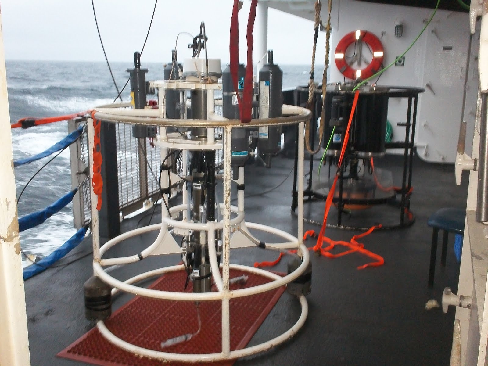
Thursday, July 22: After a night of swinging and swaying from the waves at high seas, I am somewhat used to it already. Today is the start of my new shift from 0400 in the morning until 4:00 pm in the afternoon, 12 hours on, 12 hours off. Since yesterday we left the continental shelf and we are heading to deeper waters. There was a scheduled trawl to be done early this morning, but the Acoustic Lab reported no fish at all on the screens. As part of the survey it is necessary to perform a CTD launch every morning at sunrise. CTD stands for Conductivity, Temperature, and Depth, explained Darin Jones, one of the young scientists in charge of the Pollock survey. The CTD unit is made up of a series of bottles used to collect water samples at different depths, and also includes remote sensors to collect data such as sea temperature, salinity, depth, water pressure, and fluorescence. Fluorescence is the presence of Chlorophyll in the water which depends on the amount of sunlight that penetrates the ocean, indicating the presence of Phytoplankton (algae and other microscopic plants). They rely on sunlight to produce the energy that zooplankton growth is dependent upon. Zooplankton is the foundation of the Bering Sea food chain, since is made up of krill, small shrimp like crustaceans that are the primary source of food for commercial fish such as Pollock , Cod, Salmon, and pretty much any other fish in the North Pacific Ocean. As the CTD is dropped the ship needs to stop in order lower the unit, which is attached by cables to an A-Frame crane, including one to transmit data. The CTD can only be used to depths of 600 meters, so another device called the XBT for Expendable Bathy-Thermograph (for depth and temperature) is used for depths up to 700 meters. It can also be launched manually while the ship is in motion, and data is transmitted through a thin copper wire that splits, hence the name "Expendable". Once the CTD is hauled back
 onto deck, the water bottles are drained and samples taken for dissolved oxygen (DO) analysis. DO is sequestered using chemicals that react with the oxygen taking a solid form that preserves it for lab analysis.
Personal Log:
Last night I took motion sickness pills to keep me from getting seasick. After breakfast weather got really bad, with waves up to 6 feet, battering the Oscar Dyson. These conditions, combined with a heavy breakfast, made feel really dizzy, and next I know I was throwing up. My roommate, Vince Welton, who is also the ship's tech guy, got me some very tasty saltine crackers, and medication, that help me feel better. I laid down on my bunk bed and doze off while listening to some Jazz by Michel Camilo. While trying to rest the waves were crashing into the hull of the ship with a loud noise, while the ship kept going up and down. I was thinking about how seafarers of the past and the conditions aboard were so much different than today. Ocean going trips now are made much easier by the technology and modern amenities commonly found on board. Staterooms with bath, galleys or kitchens fully equipped with fridge, microwave oven, and entertainment rooms with flat TVs and DVD players are the norm. I kept thinking that the next 2 weeks on board the Oscar Dyson will be a lot like space travel, will all the walking up and down stairs from deck to deck, closing of hatches, and not been able to step outside the ship for a walk until reaching port. The connection I can make about the CTD is that it reminds me a lot of the citizen science data collection and water quality monitoring I conduct with my students after school on the Harlem River, as part of "A Day in the Life of the Hudson River" a yearly event sponsored by NYSDEC (NY State Dept of environmental Conservation) and Columbia University Lamont-Doherty Laboratory. just like in the CTD we collect samples of water from the river to test for Dissolved Oxygen, Chlorophyll, PH, Salinity, Nitrates, plus soil samples from the mudflats. When we collect the chlorophyll samples we use the same methods just as it's done on the Oscar Dyson, squirting the water through a circular paper filter until it turns brownish. I am planning a lesson for next school year called "NOAA in the Classroom:Student CTD Activity" where using a student water sampling bottle my Environmental Science Club class will collect water from the Harlem River at different depths with the help of our wooden boat "Boca Chica" built after school. We test the samples for DO, Salinity, PH and other protocols using a LaMotte water quality test kit to monitor the health of the Harlem/Hudson River Estuary. This data will be reported to the GLOBE.gov Program website to be used by scientists and schools all over the world. My middle school MS319 is a GLOBE Program partner school, and also we will be reporting data from our new Wireless Weather Station. I strongly believe that students learn science by doing science!
"Navegando en Alta Mar"
Jueves, 22 de Julio: Hoy comence my primera guardia de las 0400 am a las 4pm. Desde que zarpamos del puerto de Dutch Harbor hacia aguas profundas me habia librado del mareo, pero finalmente me agarro.
NOAA Ship: Oscar Dyson
Mission:Summer Pollock Survey III
Geographical Area:Bering Sea
Date:Saturday, July 24, 2010
Weather from the Bridge:
Time:05:59 am
Latitude:61.42 N
Longitude:176.57 W
Wind Speed:13.44 knots
Wind Direction:90 E
Sea Temp:8.49 C (47.28 F)
Air Temp:7.0 C (44.60 F)
Barometric Pressure:1005.98 mb
Science & Technology Log:
Thursday, July 22: After a night of swinging and swaying from the waves at high seas, I am somewhat used to it already. Today is the start of my new shift from 0400 in the morning until 4:00 pm in the afternoon, 12 hours on, 12 hours off. Since yesterday we left the continental shelf and we are heading to deeper waters. There was a scheduled trawl to be done early this morning, but the Acoustic Lab reported no fish at all on the screens. As part of the survey it is necessary to perform a CTD launch every morning at sunrise. CTD stands for Conductivity, Temperature, and Depth, explained Darin Jones, one of the young scientists in charge of the Pollock survey. The CTD unit is made up of a series of bottles used to collect water samples at different depths, and also includes remote sensors to collect data such as sea temperature, salinity, depth, water pressure, and fluorescence. Fluorescence is the presence of Chlorophyll in the water which depends on the amount of sunlight that penetrates the ocean, indicating the presence of Phytoplankton (algae and other microscopic plants). They rely on sunlight to produce the energy that zooplankton growth is dependent upon. Zooplankton is the foundation of the Bering Sea food chain, since is made up of krill, small shrimp like crustaceans that are the primary source of food for commercial fish such as Pollock
 , Cod, Salmon, and pretty much any other fish in the North Pacific Ocean. As the CTD is dropped the ship needs to stop in order lower the unit, which is attached by cables to an A-Frame crane, including one to transmit data. The CTD can only be used to depths of 600 meters, so another device called the XBT for Expendable Bathy-Thermograph (for depth and temperature) is used for depths up to 700 meters. It can also be launched manually while the ship is in motion, and data is transmitted through a thin copper wire that splits, hence the name "Expendable". Once the CTD is hauled back
 onto deck, the water bottles are drained and samples taken for dissolved oxygen (DO) analysis. DO is sequestered using chemicals that react with the oxygen taking a solid form that preserves it for lab analysis.
Personal Log:
Last night I took motion sickness pills to keep me from getting seasick. After breakfast weather got really bad, with waves up to 6 feet, battering the Oscar Dyson. These conditions, combined with a heavy breakfast, made feel really dizzy, and next I know I was throwing up. My roommate, Vince Welton, who is also the ship's tech guy, got me some very tasty saltine crackers, and medication, that help me feel better. I laid down on my bunk bed and doze off while listening to some Jazz by Michel Camilo. While trying to rest the waves were crashing into the hull of the ship with a loud noise, while the ship kept going up and down. I was thinking about how seafarers of the past and the conditions aboard were so much different than today. Ocean going trips now are made much easier by the technology and modern amenities commonly found on board. Staterooms with bath, galleys or kitchens fully equipped with fridge, microwave oven, and entertainment rooms with flat TVs and DVD players are the norm. I kept thinking that the next 2 weeks on board the Oscar Dyson will be a lot like space travel, will all the walking up and down stairs from deck to deck, closing of hatches, and not been able to step outside the ship for a walk until reaching port. The connection I can make about the CTD is that it reminds me a lot of the citizen science data collection and water quality monitoring I conduct with my students after school on the Harlem River, as part of "A Day in the Life of the Hudson River" a yearly event sponsored by NYSDEC (NY State Dept of environmental Conservation) and Columbia University Lamont-Doherty Laboratory. just like in the CTD we collect samples of water from the river to test for Dissolved Oxygen, Chlorophyll, PH, Salinity, Nitrates, plus soil samples from the mudflats. When we collect the chlorophyll samples we use the same methods just as it's done on the Oscar Dyson, squirting the water through a circular paper filter until it turns brownish. I am planning a lesson for next school year called "NOAA in the Classroom:Student CTD Activity" where using a student water sampling bottle my Environmental Science Club class will collect water from the Harlem River at different depths with the help of our wooden boat "Boca Chica" built after school. We test the samples for DO, Salinity, PH and other protocols using a LaMotte water quality test kit to monitor the health of the Harlem/Hudson River Estuary. This data will be reported to the GLOBE.gov Program website to be used by scientists and schools all over the world. My middle school MS319 is a GLOBE Program partner school, and also we will be reporting data from our new Wireless Weather Station. I strongly believe that students learn science by doing science!
"Navegando en Alta Mar"

Jueves, 22 de Julio: Hoy comence my primera guardia de las 0400 am a las 4pm. Desde que zarpamos del puerto de Dutch Harbor hacia aguas profundas me habia librado del mareo, pero finalmente me agarro.
El mal tiempo de hoy temprano, con violetas olas que golpeaban la nave de hasta 18 metros, mas un desayuno muy pesado me provocaron unas nauseas que termine en mi camarote vomitando y tirado en la cama. Despues de tomarme una medicina y de comerme unas galletitas de soda, me tome una siesta y me levante mucho mejor. El Sonar Acustico de la nave no detecto presencia de peces por lo que fui a ver el lanzamiento de un CTD o unidad de Conductividad y Profundidad Termal. El CTD contiene botellas para recoger muestras de agua y sensores para medir la temperatura y salinidad del mar hasta 600 metros. Para medidas mas profundas de hasta 700 metros se usa una unidad manual desechable llamada XBT. Ambas unidades son usadas para obtener datos cientificos como el nivel de Oxygeno disuelto, Salinidad, Profundidad, y Florescencia (nivel de clorofila), la ultima es muy importante pues refleja la abundancia de algas microscopicas de las que depende el Zooplankton. El zooplankton esta compuesto de minusculos crustaceos que son la base del ecosistema alimenticio del Estrecho de Bering, del cual dependen especies comerciales como el Bacallao, Salmon y Arenque, asi como casi toda especie de pez en el Oceano Pacifico Norte. El uso del CTD es muy parecido al trabajo que hago con mis estudiantes analizando las aguas del Rio Harlem. Estos jovenes cientificos tambien toman muestras de agua y practican analisis de campo para Oxygeno disuelto, PH, Nitratos, Salinidad e incluso pruebas de Clorofila, como parte de un evento anual llamado "Un dia en la Vida del Rio Hudson" . En este evento organizado por el Laboratotio Lamont-Doherty de la Universidad Columbia, y el Depto de Conservacion del Estado de NY, participan escuelas a todo lo largo del Rio Hudson, recaudando datos cientificos sobre el rio. Pensamos usar a "BOCA CHICA",un bote de madera que armamos de tarde, para una practica de CTD tomando muestras de agua del rio, analizarlas, y reportar los datos en el internet. Tambien mis estudiantes de la Escuela Intermedia Maria Teresa Mirabal Ms319, de origen dominicano en su mayoria, aprenden ciencia ambiental al tomar datos de la Estacion Metereologica ubicada en el techo de la escuela. Ellos reportan los datos via internet en la pagina web del Programa GLOBE.gov, para ser usados por cientificos y estudiantes por todo el mundo.


